Showing posts sorted by relevance for query Park Connector. Sort by date Show all posts

Saturday, December 08, 2007

Official launch of the Eastern Coastal Park Connector Network

In 2002, the Ministry of National Development's Parks and Waterbodies Concept Plan, prepared in preparation for the Master Plan 2003, stated:
"Today, we have 40 km of park connectors. The challenge is to build 3 times more green connectors or another 120 km to complete an island-wide network by the year 2015."


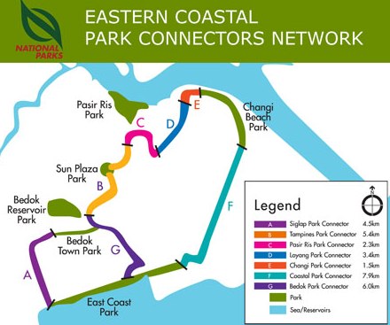
The 42km Eastern Park Connector Network was just officially launched after the completion of the 7.9km stretch between Changi Beach Park and East Coast Park. The Network comprises the Bedok, Changi, Coastal, Loyang, Pasir Ris, Siglap and Tampines park connectors.

"Scenic network in the east," by Lin Yanqin. Today, 8th Dec 2007. Parks linked by new 7.9km connector.

NO NEED to limit yourself to visiting just one park over the weekend - the newly-completed Eastern Coastal Park Connector Network will allow lovers of the outdoors to visit at least three.

The 42-km network, built at a cost of $22 million, links up the popular East Coast Park, Changi Beach Park and Pasir Ris Park, and other parks in the east, such as Bedok Reservoir Park.

Officially launched by the Minister for National Development Mah Bow Tan, the network is the first to be completed out of the planned total of seven throughout the island.

Eventually, major recreational spaces and housing estates will be connected.

The link also provides shortcuts to housing estates, Mass Rapid Transit stations and schools.

The latest stretch of the eastern network to be completed - a scenic 7.9-km route that links Changi Beach Park to East Coast Park - brings the total length of completed park connectors to 100km.


NParks Eastern Coastal Network Connector


A western park network is in the works. And upcoming inter-park connectors include the Central Catchment Area, Punggol Park and Sungei Pangsua in the west.

Said Mr Mah: "The park connector network is an important part of our plans to transform Singapore into a 'City in a Garden' ... with green lungs set among buildings and built-up facilities.

With the completion of the Eastern Coastal Park Connector Network, Singaporeans can use it to get from their homes to the parks."

For instance, Tampines residents can jog, walk or cycle their way to the popular Pasir Ris Park through the connector.

Taking a spin through the new park connector was a team of 12 cyclists from the Ministry of National Development, who were symbolically flagged off for their 25-day cycling expedition in New Zealand to raise at least $100,000 for charity.


From the Channel NewsAsia report:
By 2015, NParks hopes to construct 200km of park connectors - to date, half of that has been built. More will be added beyond 2015. NParks' eventual goal is to create a connector network linking up the whole of Singapore.

NParks said it has taken special care to preserve the natural environment. Kalthom Abdul Latiff, Assistant Director, Park Connectors and Special Projects, NParks, said, "We try to preserve the rustic nature as much as possible. We do not want to change the ambience, (we want to) keep it rustic, so that people will get a different experience."


Links:


See other park connector posts in this blog.

Wednesday, May 02, 2007

Introducing people to the joy of cycling on park connectors - Terra Outdoors (ST, 02 May 2007)

"Connecting with the great outdoors," by Tan Hui Yee. The Straits Times, 02 May 2007.

A hidden network of green-lined paths that criss-cross the whole island is just calling out to be explored, as Tan Hui Yee discovers

Unnoticed by many, there is a secret world of backlanes by quiet brooks and shaded paths that take you from the sea to the heart of the land through sleepy housing estates.

These are the park connectors in Singapore - stretching over 74km now - which allow users to run, walk or cycle from one green lung to another with ease. By 2015, the network will stretch over 170km, creating an intricate network of green-lined pathways all over this 700 sq km of an island.

Some parts are more well-used than others, but they generally don't get as much attention as the more well-known green spaces like East Coast Park.

Adventure group Terra Outdoors hopes to change that, by introducing people to the joy of cycling on these trails. Run by avid sportswomen Boey Lai Wan and Chow Suet Ling, both 29, it also conducts basic cycling courses for beginners and takes them on rides around these trails.

Ms Boey told Mind Your Body: 'It's a different way to take in Singapore. There are places that you never knew existed, where motor vehicles have no access.

'Because the park connectors are so quiet, they are good places to relax at the beginning and end of each day.'

Depending on which route you take, there are varied sights. Those who venture out west along Sungei Ulu Pandan would spot egrets, which roost at night in the compounds of the Jurong BirdPark. Herons, woodpeckers and kites can also be seen.

Venture closer to central Singapore, down the Kallang River, and you get to view the charming St Andrew's School, a cluster of conserved buildings built from the 1940s onwards.

The eastern route, which Mind Your Body explored recently with Terra Outdoors, takes you from Pasir Ris to East Coast Park. Along the way, there are mangrove swamps, a fishing pond, a reservoir, as well as an interesting undulating ride on a trail near Bedok Reservoir.

The National Parks Board plans to introduce integrated bike rental services along the eastern park connector, which links up Bedok Reservoir Park, SunPlaza Park, East Coast Park and Changi Beach Park.

This means that people may soon be able to rent a bicycle at one park and return it at another when they are done with cycling.

Park connectors are mostly flat, so cycling on them is not physically demanding. However, cyclists have to be careful to avoid pedestrians who occasionally stray into their path and be prepared to get off their bikes and push them across pedestrian crossings and overhead bridges if needed.

The routes can sometimes be blocked by construction work, so be aware of surrounding traffic when making detours on the road. As with cycling in other conditions, be sure to check your bicycle's brakes and gears before moving off, and wear a helmet as well as bright or light-coloured clothing to be more visible, especially when riding at night.

Happy wheeling!

More information on Terra Outdoors can be found at www.terraoutdoors.com


See Park Connector Maps in Habitatnews Flickr album.

Pasir Ris Park to East Coast Park
(Tampines Park, Bedok and Siglap Park connectors)


THE RIDE (ABOUT 15KM) Follow the Tampines Park Connector from Pasir Ris Park, which starts near where Sungei Tampines drains into the sea. The connector traverses the river southwards, bringing taking you past Downtown East on your left and, across Pasir Ris Drive 3, a (not really busy) fishing pond in the town park. At the Tampines Expressway, cross south and head west to continue along the connector till you reach SunPlaza (one word) Park. Follow the signs leading you to Bedok Reservoir Park through Tampines, then continue onward via Bedok Town Park to the Siglap Park Connector. You will need to cross the Pan-Island Expressway by an overhead bridge before continuing your journey alongside Siglap Canal. Along the way, you will also cross East Coast and Marine Parade roads, and pass St Patrick's School on your right. Finally, take the underpass that will lead you to East Coast Park, near Carpark 3.

THE SIGHTS There are many signs along this route to point you in the right direction. Kingfishers can be spotted along the Siglap Canal, and you will pass by a variety of housing estates – from spanking new condominiums to pleasant public housing blocks and sleepy private homes with back gates opening onto the park connector. The cluster of schools in the Marine Parade area – St Patrick's, CHIJ Katong Convent and Victoria Junior College – also make an engaging sight.

WATCH OUT Although there are many things to see, the path can be narrow at times so watch out for pedestrians. A Part of the route is involves riding through Tampines New Town, which can get quite busy and crowded. The good thing is that pavements there are divided into bike and footpaths. Take a map with you as there are many roads to cross.

Buona Vista to Jurong Hill (Ulu Pandan and Jurong connectors)
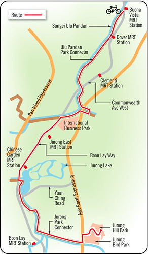

THE RIDE (ABOUT 25KM) Starting from the canal opposite Buona Vista MRT station, follow the Ulu Pandan Park Connector westwards, across Sungei Pandan, and past the International Business Park on your left. Once you hit Boon Lay Way, follow this road westwards, passing Chinese Garden MRT station and Jurong Lake on your left. Turn left into Yuan Ching Road, and get onto the Jurong Park Connector just south of Lakeside MRT station. Follow that path along Sungei Lanchar, until you reach the Ayer Rajah Expressway. Cross under the highway and you will find yourself at Jurong BirdPark. Then take a deep breath and pedal up Jurong Hill Road to reach the top of the 60m peak.

THE SIGHTS This scenic ride is a treat for birdlovers as herons, egrets, woodpeckers and even parakeets can be found in the woodlands around the Ulu Pandan connector. Jurong Lake, which you will pass, is a rest stop amidst tranquil surroundings. For those who persist till the end, there is a three-storey spiral lookout tower on top of Jurong Hill from where you can catch 360-degree views of the area. There's also a restaurant serving Japanese and Indonesian food if you need to refuel for the return journey.

WATCH OUT You will need to cycle by some roads to get from one park connector to another, as well as cross some roads, so ride safely and watch out for oncoming traffic.

Upper Boon Keng Road to Bishan Park
(Kallang Park Connector)
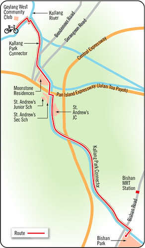


THE RIDE (ABOUT 15KM) Starting from behind Geylang West Community Club, hop on the Kallang Park Connector and follow the Kallang River northwards in the direction of Bendemeer Road (the river is crossed by a bridge near Block 14 in Upper Boon Keng Road). Cross Serangoon Road, ride past the homes in Moonstone Lane, then cross the busy Pan Island Expressway by the overhead pass close to the cluster of schools known as St Andrew's Village. Continuing along the Kallang Park Connector, you will pass Potong Pasir on your right, cross Braddell Road by the ComfortDelGro office and head north towards Bishan Park, where the route ends.

THE SIGHTS This is an efficient short-cut for residents travelling from Potong Pasir to Bishan, and passes through a number of housing estates along the way. Admire the conserved buildings in St Andrew's School and soothe those tired muscles at the Aramsa spa in Bishan Park.

WATCH OUT There are many roads and bridges to cross, so be prepared to get off your bike and push it along where it is not safe to ride. This path is mostly unshaded so it can get quite hot on a sunny day.

Kim Seng Road to East Coast Park
(promenades by Singapore River and Marina Bay, and Kallang Park Connector)
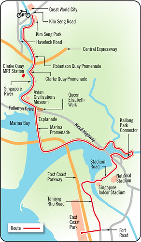


THE RIDE (ABOUT 15KM) Starting from Kim Seng Park, by Kim Seng Road opposite Great World City, you will ride along the promenade by the Singapore River, past Robertson Quay, Clarke Quay, and the Asian Civilisations Museum on your left. Cycle down Queen Elizabeth Walk, then turn right to follow the Marina Promenade on the bayfront until you hit Crawford Street. Cross Rochor River near Block 4 in Crawford Street to reach the Kallang Park Connector at the Kallang Riverside Park, and head towards Stadium Road on the opposite bank. by crossing via Geylang Road. Go past the Singapore Indoor Stadium and onto Tanjong Rhu bridge, which you ride over into Tanjong Rhu Road. That leads to Fort Road and the East Coast Park.

THE SIGHTS If you haven't had much of a life lately, this will acquaint you with many of Singapore's attractions at one go – the Singapore River, the quaint river bridges, the Asian Civilisations Museum, the Esplanade, and the soon-to-be completed giant ferris wheel, Singapore Flyer.

WATCH OUT The riverfront promenade can get quite crowded with diners and strollers in the evenings. There are also frequent road crossings and a fair number of underpasses where you are expected to dismount and push your bike across.
Sunday, October 25, 2009

Eight Parks in western Singapore now fully connected (Second PCN Loop)

Eight Parks in western Singapore now fully connected - Western Adventure PCN is the 2nd loop of park connectors to be completed; NParks media release, 25 Oct 2009 (excerpts)

Singapore, 25 October 2009 - Residents in western Singapore can look forward to a wide array of exciting recreational experiences, with the completion of the Western Adventure Park Connector Network (PCN). The 23km PCN joins eight parks in western Singapore, namely Choa Chu Kang Park, Villa Verde Park, Zhenghua Park, Dairy Farm Nature Park, Bukit Batok Nature Park, Bukit Batok Town Park, Limbang Park and Bukit Panjang Park.

It is the second loop of park connectors to be completed, after the Eastern Coastal PCN in December 2007. Five more loops of park connectors are in the pipeline. Once completed, the park connectors will form a green matrix, connecting major parks and nature sites and providing users with a choice of landscapes and distances for recreation.

Diverse range of adventures and experiences along PCN

The Western Adventure PCN offers a diverse range of recreational experiences, to cater to all types of users, from adventure-seekers to nature lovers and families. Some of the activities include:

For Adventure-Seekers
  • Mountain biking at Zhenghua Park and Dairy Farm Nature Park
  • Rock Climbing at Dairy Farm Quarry
  • Hiking at Bukit Timah Nature Reserve and Zhenghua Park

For Nature Enthusiasts & Photographers
  • Scenic lookouts at Bukit Batok Town Park ('Little Guilin') and Bukit Batok Nature Park
  • Bird Watching & photography along Bukit Panjang Park Connector, Zhenghua Park and Bukit Batok Nature Park.
  • Butterfly spotting along Pang Sua Park Connector

For Families
  • Regional parks, such as Choa Chu Kang Park, offer family-oriented facilities such as playgrounds and fitness corners
  • Learning about a slice of Singapore's history along Hillview Park Connector (where the Ford Motor factory is a short distance away)
  • Wallace Education Centre and nature trail at Dairy Farm Nature Park
  • Leisure activities along Pang Sua Park Connector

Rich biodiversity along Western Adventure PCN

The Western Adventure PCN is home to a wide variety of flora and fauna, a result of the 550 species of butterfly and birds-attracting trees which have been planted at various stretches along the PCN. They include Pang Sua, Choa Chu Kang, Choa Chu Kang North and Bukit Panjang Park Connectors.

Over 10 species of butterflies and 50 species of birds have been sighted along the PCN. The birds include the singing Zebra Dove; the Tiger Shrike, a winter visitor with tiger-like black bars pattern; and the Oriental White-eye which is characterised by a white ring around the eye. To promote awareness of the rich biodiversity of birds, NParks will be working with Nature Society to conduct bird watching activities for Singapore residents at the PCN.

PCN Programme on Track

Implemented by NParks, the PCN is an island-wide network of linear open spaces around major residential areas, linking up parks and nature sites in Singapore. It brings people closer to parks and nature areas, enhancing recreational opportunities for all and is an important part of our plans to evolve Singapore into a "City in a Garden."

To date, over 110km of park connectors have been completed, with 63km currently in construction. The PCN implementation programme is on track. By 2015, NParks aims to develop a 300km island-wide network of green corridors around the island.

PCN Friends - Active Citizenry in Action

To keep PCN users updated and engaged on activities and latest happenings along our park connectors, NParks has formed a group in late 2008 called 'PCN Friends'. NParks has sought feedback from the group members on ensuring that there is sufficient signage along our park connectors. Selected group members were also invited to test-out selective stretches of the Western Adventure PCN earlier this year.

Since 2007, NParks has establishing a common identity for PCN to guide and inform users through standardised signboards, directional signs, PCN streetprints and destination markers.

Thanks to WildSingapore!

Monday, June 02, 2008

Park 'dis-connectors' are really just jogging or cycling paths: letter

"Park 'dis-connectors' not for jogging or cycling," letter by Liang Wern Kang. The Straits Times forum page, 02 Jun 08.

"I READ with interest about the recent Leisure Plan by the Urban Redevelopment Authority (URA). Under the plan, 260km of park connectors will be added in the next 10 to 15 years.

I have always wondered what a park connector is. Let me recount what I encountered the other day. I was cycling along the Ulu Pandan Park Connector from beneath Commonwealth Avenue West towards the Ayer Rajah Expressway (AYE).

When I was about 50m from the AYE, the path tapered into a patch of wild grass. A sign read: 'This is the end of park connector. For your own safety, please do not go beyond this point.'

From the NParks website, the Ulu Pandan Park Connector is T-shaped and has three end points: Bukit Batok East Avenue 2 near Bukit Batok Nature Park, the AYE near Pandan Reservoir, and Commonwealth Avenue West near Buona Vista MRT station.

I can see the last stretch of path next to Pandan Gardens that goes towards Pandan Reservoir, and another stretch of path next to the International Business Park that goes towards Bukit Batok. However, they are not 'connected' to the path I was on, separated by the AYE and Pandan River.

So was I cycling in a park or a connector? If it was a park, where is the connector that connects the other two 'parks'? If it was a connector, which parks is it supposed to connect? Pandan Reservoir and Bukit Batok Nature Park?

Park connectors have been around for some time, but jogging and cycling paths remain isolated. My neighbour who works in the International Business Park told me it would take him five minutes to cycle to work if the paths were connected. Instead, he has to drive or take public transport, which takes him 15 to 30 minutes and adds to traffic congestion.

I look forward to when park connectors truly connect, even if it means underground tunnels or wheelchair-friendly bridges, as this will help the environment, our health, traffic and economy in the long run.

If there are no plans to connect all these paths, call them what they really are: jogging or cycling paths."

Sunday, May 27, 2012

19.5km of new park connector to create a 30km loop around the nature reserve by 2018

A new 19.5km park connector will link the existing 5.5km bike trail and 5km Mandai Road park connector to create a car-free space for recreational cyclists to loop around the periphery of the Central Catchment Nature Reserve.

30km Park Connector map2
"Bringing nature closer to residents with 30km cycling loop," by Amelia Tan, The Straits Times, 27 May 2012.In the pipeline: 80ha park, viewing towers, 30km cycling loop at central catchment area
Nature buffs will have greater access to flora and fauna in Singapore with a 30km cycling loop to be completed by 2018.

The circuit will go around the Central Catchment Nature Reserve which covers the Upper Seletar, Upper and Lower Peirce, and MacRitchie reservoirs.

It will be formed by joining 10.5km of existing park connectors and biking trails that go around the northern and western borders of Central Catchment Nature Reserve to a new 19.5km park connector. This connector will encircle the reserve's southern and eastern borders.

The new cycling loop was announced on Saturday by Minister of State for National Development and Manpower Tan Chuan-Jin at the launch of the Festival of Biodiversity at the Singapore Botanic Gardens.

He also announced that the Government will be developing a new 80ha park, named the Chestnut Nature Park, just outside of the Central Catchment Nature Reserve.

The park, which will be ready by 2015, will have forest trails, shelters and educational signs.

Two seven-storey towers will also be built to allow nature lovers to enjoy panoramic views of the Central Catchment Nature Reserve.

One tower will be located in the Chestnut Nature Park and the other will be built by 2018 in MacRitchie Reservoir Park.

Mr Tan said the developments are part of the Government's objective of bringing people closer to nature and noted that almost half of Singapore land's surface is covered by greenery.

He said: 'Our parks are easily accessed by residents, with most homes within a short walking distance of a park. That is something that we'll work towards.'

He said the Government will continue to engage Singaporeans on new ideas about adding diversity to the urban environment.

He added: 'There will be areas where we can't always agree on, but there is also so much more space that you have found that we can work on together.'

Commenting on the new developments, National Parks Board director of conservation Wong Tuan Wah said: 'Some people say they have no time to enjoy the outdoors. Since you have no time, we will bring the outdoors to you. And if you have more time, we can help you to learn more with things like signages at the parks.'

The cost of the new developments is not confirmed.

Nature groups and the public welcomed the new plans.
Dr Shawn Lum, president of the Nature Society (Singapore), said: 'The Chestnut area is rich in biodiversity but is currently visited mostly by scientists or serious nature buffs. I think more people will be encouraged to visit the area in the future because of the park; it makes it more accessible.'

Teacher Germaine Foo, 46, said: 'I will consider getting my children to use the cycling loop in the future during their school holidays because part of it is near our home in Yio Chu Kang.'

On Saturday was the start of the two-day Festival of Biodiversity. The event, held at the Singapore Botanic Gardens, features exhibitions, workshops and guided tours for the public.

President Tony Tan Keng Yam launched the festival on Saturday.


---
Photo taken at the launch of the festival.

Monday, April 18, 2011

Singapore Park Connectors: cyclists can wheel out bike trail tips," by Feng Zengkun. The Straits Times 18 Apr 2011.NParks invites them to plug scenic spots, offer ideas to improve network
ST Graphics-Park Connectors
Click for larger image

CYCLING routes by the people, for the people.
By the year's end, cyclists in the park connectors here will have access to recommendations - provided by their fellow cyclists - to restaurants, heritage spots and scenic views along these biking trails.

Beyond this, cyclists and other park connector users will also be encouraged to offer ideas to improve the network, said Mr Bernard Lim, the assistant director of the National Parks Board's (NParks) Park Connector Network.

The information on the network, which will eventually take cyclists from Bukit Timah to Marina Bay, will be posted on the NParks website.

The data-banking is off to a rolling start.

Since NParks launched an online feedback form for members of the public in January, it has received about 10 replies a week; it also keeps in touch with local cycling groups here for their input.

Retiree Mina Chan and her friends form one such 'resource' group. Aged between 40 and 60, these avid cyclists try out a different park connector every weekend, and, for the last five years, have offered NParks updates on the condition of the tracks and alerted it to danger spots.

Ms Chan already has a route to recommend to fellow cyclists - the waterfront stretch between Alexandra Canal and the Singapore Flyer.

Another cyclist, Mr Han Jok Kwang, 56, has petitioned NParks successfully to keep the gravel stretch through hilly terrain in the western loop connector.

'I asked NParks to keep it because it gives cyclists variety,' he said.

Mr Lim said that, without Mr Han's petition, NParks may have levelled the terrain and laid tarmac so everyone - even beginner cyclists - can use it.

NParks considers suggestions as long as they do not compromise safety, he said, although such assessments can be subjective.

He said the call for input from cyclists aims to make the routes more personal for users of the park connectors. 'We spent the first few years building up the infrastructure; now let's see what else we can do with it,' he said.

The Park Connector Network consists of seven parts, to be developed by 2015 (see graphic). By then, it will have 300km of bike paths.

Mr Lim said, with the cycling community contributing information, the pan-island network can be made safer too.

'Our employees and sub-contractors check the routes every day but they cannot cover everything because the routes are too long. Having more eyes helps us catch more things.'

Mr Pan Wee Yeow, a retiree who rides twice a week, said seasoned cyclists can identify problems before injuries occur. These include blind corners that need mirrors to be set up and where speed-reducing strips may be advised. He added that regular cyclists can also spot growing problems that may otherwise go unnoticed, such as faulty lighting or algae on the paths, which makes them slippery.

NParks said it fixes minor problems such as faulty lights within two days of being notified; problems requiring more work, such as levelling bike paths to prevent jarring bumps, may take up to a week.

Mr Pan hailed NParks' move to get the public involved, given that more people are taking up cycling.

There are no statistics on the cycling population here, but cycling clubs say the number of people on two-wheelers has exploded in the last five years.

The OCBC Cycle Singapore event last month, a ride of up to 60km along East Coast Park, attracted more than 10,000 participants, twice the number two years ago.

For Mr Han, cycling is about going back to a simpler pastime.

He said: 'We have the integrated resorts, gadgets, all the fancy diversions. Sometimes, things don't need to be so high-tech. Sometimes, all you need is a road and a bike.'

Members of the public may e-mail nparks_mailbox@nparks.gov.sg to join NParks' mailing list and to get the link to the feedback form.

Tuesday, March 13, 2012

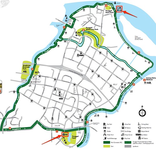
Rent a bicycle and ride along Sungei Punggol and Sungei Serangoon (North-Eastern Riverine Loop)

The North-Eastern Riverine Loop was just opened and features views of the Punggol and Serangoon Reservoirs, linking Hougang, Punggol and Sengkang towns and the following sites:
  • Punggol Point Park (road end)
  • Punggol Promenade
  • Punggol Beach
  • Punggol Waterway Park
  • Sengkang Riverside Park
  • Punggol Park (off Hougang Ave 10)
  • Lor Halus Wetland


Six existing park connectors are linked:
  • Punggol Park Connector,
  • Punggol Promenade,
  • Serangoon Park Connector,
  • Sungei Serangoon Park Connector,
  • Buangkok Park Connector and
  • Punggol Waterway.

Download the e-guide from NParks here.

The best way to enjoy the 26km trail is in the evening when the sun is setting over the west. And the good news - you can rent a bicycle if you do not have one either at

  • Punggol Point Park in the north - map link; bus no 84).
  • Punggol Park in the south - map link; bus nos. 62, 74, 113, 119, 147, 74E; 80, 82, 87, 88, 89, 119, 89E, NR6)

The map below (click to enlarge) shows you the locations of these bicycle rental kiosks, thanks to Trina Chua from NParks for the information.

Both bicycle rental kiosks are open; timings:

  • Tue to Fri from 2pm to 8pm and
  • Sat and Sun from 9am to 8pm.

Note that you have to return the bicycles from the kiosk you borrowed it from, i.e. they are independent of each other. A leisurely 26km ride with stops might take 3-hours (there is a 15 km/h speed limit), so do plan your ride well - come by the park and rent your bicycle by 5pm if you intend to take in the sights and grab some photos.

Now, get on that bike and ride!

Links

  • Photos from NERL - Alvin WOn, 22 Jul 2012
  • "Biking to Punggol Promenade on 26 October 2011," by Ng Cher Choon. Biking Experiences, 14 Nov 2011 - link.
  • Walter Lim blogs about the launch of NERL with lots of photos at Coolest Insights.
  • NParks press release, 25 Feb 2011 - link.
  • NParks e-guide link

Friday, February 01, 2008

Cycling the Eastern Coastal Park Connector Network

The Eastern Coastal Park Connector Network is a new and rare cycling refuge has been well used by regular cyclists, particularly the stretch along the coast between Changi and ECP.


Read what they say:

Monday, January 18, 2010

Westward Ho! A safe ride on the Western Park Connector, which links eight parks

While the debate about cycling to work ensues, the quiet and continued improvements to the park connector network promise to enhance the leisure cycling population of Singapore in the years ahead. After almost two decades, there is a safe way for the leisure cyclists to take to the streets and it is a cause for celebration!

132zendogs-westernPCN-10jan2010 on Flickr - Photo Sharing!

083zendogs-westernPCN-10jan2010 on Flickr - Photo Sharing!


If a path near your home has the PCN mark, rest assured you have a link to much wider and safe routes. Eventually this number will venture to the roads and join the call for better conditions on the road for cyclists and help to ponder the solutions.


022zendogs-westernPCN-10jan2010 on Flickr - Photo Sharing!


Ever since I heard that eight parks in the west were connected, I have been itching to give the Western Park Connector Network a twhirl. So two Sundays ago I headed out and the critical new addition? A bridge over the PIE! Now it is possible to cycle from Ghim Moh to Choa Chu Kang and Dairy Farm - all without fighting traffic! Yes, there is a safe reason to dust off that old bicycle now.


My fellow Zendog, Chi had scouted the route and along with Cat, Airani and Aaron, we took a slow ride (average speed 13km/h) through the Western PCN. Despite the lack of a sea view, athe western route is topographically more interesting than the coastal part of the eastern PCN, which connects Pasir Ris to Fort Road.

001zendogs-westernPCN-10jan2010 on Flickr - Photo Sharing!

Flickr Photo Download: 195zendogs-westernPCN-10jan2010


Our route that day included Dairy Farm, Bt Batok, Jurong, Choa Chu Kang, Pang Sua, Bt Panjang and Zhenghua. The links are smooth and much of the route is shaded. The government has certainly invested a lot of money in the PCN and it was quite a privilege to enjoy the ride! It's surely time for the average Joe to buy a bike and enjoy the plantings, routes and scenes - touring the neighbourhoods would definitely be an eye-opener for people from other parts of the island.


Zendogs are pretty familiar with the west, but even for us there are always new things and people to observe - a man was quarreling with a crow, whom he said had pecked his head. When we left he was still brandishing his slipper - and the bird was following him - quite a personal altercation!


There are some pedestrian clusters through which you have to ride slowly or even dismount unless skillful enough to ride at a walking pace. Interestingly, people at these clusters were comfortable with our bikes, with no signs of nervousness that is sometimes observed elsewhere. We rode slowly, of course, extending to pedestrians the sort of courtesy we would like to receive from vehicles on the road. Since we were at a walking pace in some instances, we could even chat with some pedestrians!


All along, the route was well signposted. The connections were really easy to make as well.


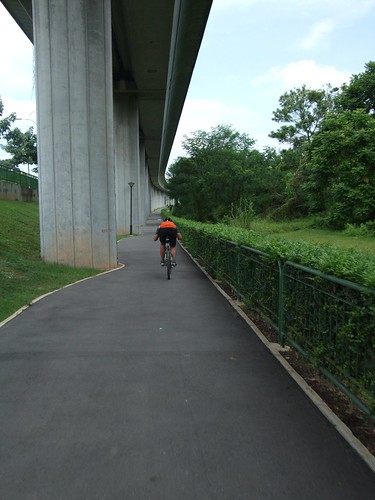
The Hillview Park Connector is a converted pavements for most of its length which run past condo entrances - these require cyclists to be alert about vehicles entering and leaving their premises. Since it was a quiet morning, I switched to the wide road, a better option here, I felt. Thankfully, most of the connectors are alongside rivers (canals) and MRT tracks - these were heavenly!


I only had an hour's sleep the night before and had a lingering cough but the rest had assured me a comfortable ride. True enough, I enjoyed the ride and covered 46km. The last bit through Zhenghua Park heralds the end with a rustic feel complemented by the design of the benches and playground and the type of plants - rainforest tree species which were planted, for a majestic future.

Flickr Photo Download: 185zendogs-westernPCN-10jan2010


So what are you waiting for? Buy a bicycle and tour the west! In future the other PCNs will just as well be connected up. When the PCNs are then all linked, a leisure cycling paradise awaits you. It will be a great way to get to know Singapore. Meanwhile, my verdict? Five stars, out of five!

Nokia Sports Tracker Beta


Links
  • Photo album of my ride - link

  • NParks: Park Connector Network - link

Tuesday, March 18, 2014

"That last leg can kill you" / Make Clementi the next cycling town - in my lifetime please

See the URA Draft Master Plan 2013: "Cycling For All"

Kevin Lam Koi Yau wrote to The Straits Times Forum page (17 Mar 2014) to say,

Make Clementi the next cycling town

It is a good idea to promote intra-town cycling in selected Housing Board towns. But I am disappointed that Clementi has not been selected among the latest batch of cycling towns.

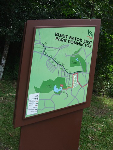
With its close proximity to the Ulu Pandan park connector - which links with the Jurong park connector, Bukit Batok Nature Park, International Business Park, Dover MRT and Boon Lay MRT - and schools such as the National University of Singapore, Singapore Polytechnic and Ngee Ann Polytechnic, Clementi could benefit greatly from a well-thought-out cycling infrastructure, which could ease public transport woes during peak hours as well as get our young people to adopt an active lifestyle.

An avid cyclist once told me not to commute to NUS for work, though I live in Clementi, as there are no safe routes.

I urge the Land Transport Authority to consider investing in cycling infrastructure in Clementi to boost safety for cyclists and get more people to take up cycling.

That last leg can kill you

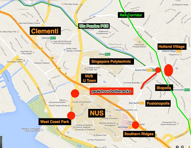
Kevin reminded me I am that cyclist who told him not to cycle to NUS. And my advice still holds. There is a great improvement in connectivity in the area compared to the eighties, carved out mostly by NParks' Park Connector Network and enhance by the Rail Corridor which we all hope is here to stay.

While there is a decent connectivity, that last leg can kill you! Approaching NUS via Clementi Road or South Buona Vista is harzadous. This is not recommended for a daily commute.

NUS' U Town has now opened up a pavement route alongside Clementi Road if you are using the Ulu Pandan Park Connector. It is not a fast route, but a relatively safe one. But this will not encourage commuting in an area filled with potential cycling commuters, parking and shower facilities. I have shared these ideas with URA through the National Cycling Plan dialogue but I do think this area is a tough one to begin a cycling infrastructure enhancement project. Not a low hanging fruit.

Still, the Clementi - NUS - Holland Village area needs a makeover. The problems in this area exceed cycling infrastructure for sure. Still, one relief to the daily congestion would be by facilitating cycling.

Will the National Cycling Plan come to town, and in my lifetime, please?


URA Draft Master Plan 2013: National Cycling Plan
Intra-Town Cycling Paths - All Towns To Be Cycling Towns

Off-road intra-town cycling paths will allow residents to cycle safely from their homes to major transport hubs and key amenities such as food centres, schools, supermarkets and community centres within the town.

By 2015, 100 km of intra-town cycling paths will have been developed in several cycling towns [Tampines, Sembawang, Bedok, Changi-Simei, Pasir Ris, Taman Jurong, Yishun, East Coast, Jurong Lake District, Marina Bay and Punggol]

.

Another 90 km of cycling paths will be added to more towns by 2020. The aim is to provide all 26 HDB towns across Singapore with comprehensive intra-town cycling networks for residents to cycle to and from MRT stations and neighbourhood centres.

Wednesday, March 11, 2009

Rent and return bicycles between Changi and ECP

Six new bicycle kiosks have opened along the Eastern Coastal Park Connector Network. These allow the rental and return of bicycles at any of the six kiosks, so a weak cyclist who has made his first enjoyable ride to East Coast Park does not have to dread the 8km ride back to Changi to return the bicycle - he just needs to return it to the relevant kiosk in ECP.

Of the entire PCN, it is the Changi Beach Park to East Coast Park stretch which I recommend to friends out to get a taste of cycling in Singapore. The scenery is nice and the route is very safe with only three junction crossings. The inland parts of the PCN are less hospitable so is best explored later when their cycling skills have improved and they want to explore. Rental rates are $5/hour.

Pity there is no Pasir Ris Park station though. The stations are at:

  • Sun Plaza Park (Tampines)

  • Changi Beach Park Area Car Park 1,

  • Changi Beach Park Car Park 7

  • East Coast Park Area G

  • East Coast Park Area C,

  • Telok Kurau Park

    http://www.straitstimes.com:80/STI/STIMEDIA/pdf/20090310/b3-rentridereturn.pdf


    "No need to backtrack to return rental bike," by Maria Almenoar. The Straits Times, 10 March 2009.

    A NEW spin on recreational cycling has hit the four connected parks on the East Coast.
    Six new bicycle rental kiosks strung out along the bike paths now allow cyclists to pick up and drop off their rented wheels at any of these pit stops.

    Bye bye to the need to backtrack to the kiosk from which the bicycle was rented, as is the required practice with bike rental stations now.

    The National Parks Board (NParks) awarded the tender to run the new service to Lifestyle Recreation, a company which has been renting out bicycles and in-line skates at the East Coast Park since 2001.

    Its kiosks can be found at East Coast Park Area C, East Coast Park Area G, Changi Beach Park Area Car Park 1, Sun Plaza Park, Changi Beach Park Car Park 7 and Telok Kurau Park. Two more may be set up in the Bedok and Pasir Ris town parks.

    Rental rates are comparable to other rental outlets in the area - $5 an hour for a bike and $10 an hour for a tandem bicycle. A cyclist needs to produce his or her identity card to rent a bike.

    Lifestyle Recreation is also looking into providing an all-day service in which a cyclist picks up a bike and can return it even after the rental stations have closed for the day.

    A cyclist who plans on returning the bike late first books and pays for the rental online. A bicycle number and code to the bicycle lock is then sent to him in a text message.

    Ms Susanna Tay, Lifestyle Recreation's managing director, said: 'When NParks opened the new park connectors, we knew that cyclists did not want to be restricted on where they could ride, so this is a value-added service we can provide.'

    She added that the company may allow the same rental arrangement for in-line skates if there is a demand.

    Photographer Alex Wee, 35, who heads to East Coast Park every two months for cycling, is now game to explore the East Coast's four parks.

    He said: 'Usually you don't get to cycle far and see much because you have to backtrack to return the bicycle. They should consider having a public transport link at either end as well.'

Monday, April 15, 2013

Ivan Chew's suggestions for the Khatib Bongsu Park Connector

Ivan Chew at the Rambling Librarian writes,
"I love our Park Connectors. I ride on the Khatib Bongsu park connector most often (sometimes connecting all the way to Woodlands Waterfront, through the Admiralty connector). I've noticed minor improvements to the Khatib Bongsu connector in the last two years. But there's still room for improvements. "
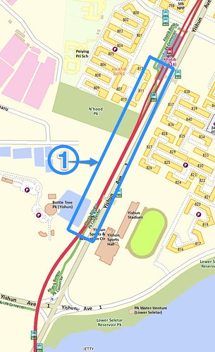
And he goes on to detail the suggestions for seven sections of the Khatib Bongsu Park Connector, with illustrations such as this one:
If you have suggestions about your favourite PCN, blog about it and let me know, I'll highlight it here and forward the links to URA and any other relevant agency. Thanks Ivan!

Thursday, February 09, 2006

"Cycling track or obstacle course?"

"Cycling track or obstacle course?"
Letter from Elke Eskes-Frey. Today, 09 Feb 2006.
Pedestrian bridges along park connector give cyclists a back-breaking experience.

I grew up in an environmentally-conscious nation where people cycle not only to exercise, but also to commute and save energy — even if they have two cars at home. So, perhaps I was spoilt to think that I have rights on the road as a cyclist.

I don't cycle here because of drivers who hoot or push me off the road. I tried in the beginning, but soon found that I am too exposed to the risk of sudden death on the street, and am barely tolerated on the sidewalk. Until recently, I had not found any cycle track outside a park, which made it impossible to cycle with pleasure from one point to another.

But then, a stroke of luck: I picked up a map that informed me of the Government's plan to build a park connector network that will span over 300km once completed for pedestrians and cyclists alike.

I dusted off my bike and went to explore the already-completed Kallang and Whampoa connector. I could see myself riding, long hair blowing in the wind, along parks and canals.

But I ended up finding myself carrying the bike on my back, up and down one pedestrian bridge after another, finally reaching the Toa Payoh bridge with its six flights of stairs (or was it only five?).

My hair got covered in sweat and car fumes and could not even dry out in the short cycling stretches between the crossings.

Don't get me wrong — the ride was fun and educational. I learned about the concept of having numerous "No riding on bicycle" or "Get off bicycle" signs on a cycle track!

And I now know that Singapore's new park connector "caters to cyclists who prefer longer distances" — and especially to those who prefer carrying their beloved bike around for even longer ones.

Tuesday, September 16, 2003

Thoughts about cycling in Singapore

I was part of a URA Subject Group to provide feedback to URA/NParks about the Parks & Waterbodies and Rustic Coast Draft Concept Plan. This was fed into the Master Plan 2003 subsequently. I spoke up for cyclists/skaters where relevant. No one was against sensible suggestions in this objective group but they were active citizenry, not government.

Suggestions ultimately have to be implemented and if attention is drawn to it, it gets some priority, especially by multi-tasking departments.

I have been mulling over some ideas, and here they are off the top of my head:

  • Leisure cyclists do not have a coherent voice, but I see now gradual changes in SACA; SMURFS and Togoparts are a very good development.

  • There are not enough events for regular folk. We have a few mass cycling but none on ride safety for HDB town riders. Groups like BOAC bikers contribute a lot and are very important. We need more to pop up. I know there are a few out there, I met them during some public rides.

  • Thanks to the internet and sites like togoparts, there is already a lot of basic information about bike shops etc. All this helps.

  • We must harness our voices with others who share common desires, e.g. Other park connector users: joggers, walkers, nature lovers, students. Mountain bikers should see how they can integrate their desires with naturalists. Park Watch groups have been formed to take a social role in their parks. We can contribute in some, e.g. in East Coast Park this has begun.

  • By not having a significant profile and reach amongst citizenry and their leaders, not enough people are speaking up at opportune moments ≠ squeaky wheel gets the grease.

  • Park connectors make up some 40km. Another 120km by 2015- not promised but it will be "a challenge" to realise this. We have to ensure the public enjoys the rewards of a park connector ≠ fresh air, less dust, a place of serenity, more plant and animal life nature, impression of space in a small country, connectivity between neighbourhoods. NParks has been on their own so fasr. E.g. there are RC leaders who believe park connectors should be provided with the connectivity despite the expense. I had balked at the cost of an underpass inane discussion, but he said it was a matter of priority, which merely depends on outlook.

  • The current state of park connectors has issues - they are blocked at a whim in some parts, they are not connected when they could be - we need to examine these and begin to take action in a small way.

  • There are mature plans overseas which have considered some of these ideas (urbanised cities have the same space issues) and I am looking for such information for ideas when I can.

  • I am not the idealist or visionary to think of inserting cycling lanes on Singapore roads. But how about cycling lanes in the very wide and frequently used roads for cycling such as Changi Coastal Road or Thomson Road, that is not too demanding? Are there not accidents at Changi Coastal Road?

  • Use such a proposal to find out who can and will do things, or who won't. Personal networking is very important. To get hints about timing to pitch, people to avoid and others to hunt down!

  • The cyclistÏ€s image is bad in places like pavements in Punggol; mountain biking in some parts - exclusive or inconsiderate. Embrace a code of conduct. E.g. On pavements, park connectors, anywhere, the cyclists should give way to the pedestrian - and this also means not alarming them by loud warnings from behind. Race management must be done effectively yet politely so we do not antagonise others. Bikers should be more considerate when they go offroad. I see some sensible suggestions on Togoparts recently about riding safely.

  • We need bike clinics about traffic riding. That SMURFS group did a great job for introductory mountain biking. We need one for riding with traffic, as opposed to mountain biking, road riding and urban cycling. These are terms I use to differentiate the classes of cycling because they require different approaches and techniques; there may be proper names for these. For traffic riding, I still profit from my compulsory motorbike lessons for Class 2B and Highway Code taken some 16 years ago! You need to adapt those for bicycling. Even so-called experienced riders can profit from this from my observations.

  • If we don't care about others, should they care about us? It is easy to dismiss the needs of an unpopular group. How many are even thankful for mass rides organised for them like Leisure Cycling and Runway Cycling! A code of conduct might serve to build up an awareness of what is "not cool" to do. The inconsiderate cyclist is bringing disrepute to every other cyclist and closing the minds of the necessary people. Not everyone is objective enough to see past an unpleasant incident.

  • Cycling must have a more mainstream image than it has now. I seem to feel (but am not sure) this happening. Alvin was apparently working to get cycling recognised in NTU. We need more like him. I have friends in SACA who are trying with schools.

  • NTU's Round Island Cycling is the sort of event that we need to see more of. It was a hospitable environment in which beginners at long distance can safely tackle a round island ride. What you might expect from a national organiser level, but they did it. Kudos to the NTU students. I went up to them and thanked them and also emailed them my thanks again later. I wonder how many did. Some of friends did make the effort but our culture for acknowledgement is poor, although it can significantly motivate.

  • If any of us have a strategy or set of ideas which are coherent and practical get input from friends and send it the papers, SACA and the relevant government department. Then follow up on it. Individual action is also helpful.

  • Share thoughts with the cycling community, who must come to be socially conscious enough to understand such approaches. We must be able to talk about it to friends and colleagues. If it is non-confrontational, embracing of other communities (naturalists, joggers, walkers, etc) needs, sensible, practical and not too demanding, it has a good chance of even recruiting advocates.

  • It means compromise: you cannot sprint on a park connector filled with people. How many riders grumble abut how slow cycling is on East Coast park? There are good bits with the bad.

  • In Togoparts I see some young ones who appear to understand this already. It's a good sign. They are getting familiar with the methods. They'd better, this is their fight too.

  • Some nature conservation results were 15-years in the making. I feel the environment is now more hospitable to such a social process. What took a decade may now take half the time. Of course good timing helps. Will cyclists stand up and make a difference for themselves? There will always be drunk drivers.


Ride safe all.

Sivasothi

First posted in Otterman speaks.

Monday, August 09, 2010

Have foldable bike will travel (on PCN)

The Park Connector Network in Singapore has opened up safe route to cyclists like never before. These traffic-free paths are safe for cyclists who just need keep an eye open for pedestrians and the mostly few intersections with traffic. Their increasing pervasiveness provides not only safe commuting and leisure cycling opportunities but also the joy of touring Singapore much like you would as a tourist in a foreign land.

Park Connector Network


Meanwhile, foldable bikes have offered space-scarce Singaporeans the solution to owning and transporting bicycles. Some are small enough to be allowed on the MRT during off-peak hours while others are simply convenient for storage. Foldables are so popular, neighbourhood shops are offering cheap versions for the casual cyclist.

This combination may help the rise of cycling as a leisure and commuting option for Singaporeans. Enough for me to spout, "have foldable bike will travel".

Ivan Chew, the Rambling Librarian, exemplifies this. I was heartened when he sent me news about his $135 bicycle purchase and subsequent exploration of Mandai:

"I bought foldable bike at my neighbourhood bike shop on 22 July 2010. The bike is a relatively cheap China production but construction and workmanship isn't shoddy. It cost me $182, including $47 accessories like a side handlebar mirror and 2 lights.

I suspect it's a blatant ripoff of a Dahon foldable bike but still, this meets my needs."

skitched-20100809-112242.jpg


"I bought the bicycle because I saw the Mandai PCN from a bus one evening. I had thought to myself that I can finally cycle out of Yishun, safely on a PCN. So I took it for a test-ride the next evening at about 9.30pm.

I rode the Khatib Bongsu PCN, starting from Yishun Park to junction of Yishun Ave 1 & 2, and then rode towards a new Mandai PCN that is not yet reflected on the NParks map. I rode this all the way to the Seletar Expressway flyover.

Park Connector Network - Yishun-Mandai


Then I hit Mandai Ave all the way to the turning point towards Mandai Crematorium. By this time it was edging towards midnight (work day next morning) so I decided to turn home. I am crossing my fingers we'll see the PCN fully connected in 5 year's time.

I'm not confident enough to cycle on the roads. But I don't like crowding pedestrians on paths (I'm a pedestrian most times!) So the PCN is REALLY a boon. NParks really scored big with me. And you can quote me on this :)"
Ivan Chew's foldable bicycle tucked away
Happy National Day everyone!
NDP 2010

Ivan Chew's response here.

Saturday, July 05, 2008

Park Connector Networks - Singeo provides Google Maps/Earth derivations

In my last post highlighting NParks new page for the Park Connector Networks, most savvy-users would have realised the lack of ability to manipulate manipulation teh maps significantly nor any linkage to Google Maps and the litany of advantages that provides including the ability to download data to Google Earth.

So I asked for help and SinGeo poked around and found the coordinates for the entire in the page source. Its something I have been using for park locations (see Habitatnews). In this case he grabbed the polylines and plotted them on both Google Maps and Google Earth - go fetch like I did. It will help with your own maps.

Do note that these park connector polylines were not new plots but a downlaod from NParks. This means its approximate for the most part. Do help to refine them if you can.

http___www.singeo.com.sg_singeo_kmz_pcn.kml - Google Maps


Friday, January 20, 2012

Join the TTSH Family & Friends Charity Ride on Sat 25 Feb 2012 and raise funds for needy sick elderly

TTSH FFCR

The Tan Tock Seng Hospital Community Charity Fund is organising a Family & Friends Charity Ride in conjunction with the launch of a Park Connector in the Northeastern part of Singapore by the National Parks Board (NParks).

About the Event
The event will be held on on Saturday 25 February 2012 from 8.30am to 12.00pm. Cyclists will ride along a 9 or 11km Park Connector to enjoy the beautiful green space and waterways. Deputy Prime Minister Mr Teo Chee Hean will be the Guest-of-Honour of the NParks event. There will also be a Carnival in the Park for the community to join in the celebration. More than just a fun outing or morning exercise in the park connector, the event also aims to raise at least $100,000 for our needy elderly patients who require long-term medication and treatment in TTSH.

Registration
Individual registration fee is $50 and groups of FOUR and above need only to pay $30 per person. Payment is by cheque, paypal or cash at TTSH. All participants will receive a T-shirt and a goodie bag worth $50. Rental of Bike is available on event day at $10 per bicycle (payable onsite). More information is available on http://ttshcharityride.com.

Sunday, November 10, 2013

Singapore still lacks the ride stuff

By Toh Yong Chuan Senior Correspondent
Straits Time 2013-11-09

More than 500 cities in the world have bicycle-sharing schemes. Singapore is not among them.
Although the Government announced bold plans last month to build a staggering 700km of cycling paths by 2030 - the equivalent of cycling from Singapore to Kuala Lumpur and back - that alone will not make Singapore a cycling city.
We have fallen behind other cities that actively promote cycling as a mode of transport. There are various reasons why we should pedal hard to catch up.
Cycling is a green option that can be an efficient people-mover for transport planners.
A cycling census in London this year found that one in four road users in the morning peak period is a cyclist. For some popular roads, as many as three in five vehicles in the morning rush hour were bikes.
Bikes take up proportionately less road space than cars. Given that the road network here cannot expand indefinitely, cycling paths provide a logical option even as we expand our train and public bus networks.
Cycling also encourages interaction and it can be a social leveller. Cars cocoon drivers and disconnect them from other road users. In contrast, there are no physical barriers between cyclists and they have to share space.
I was part of a three-man reporting team that rode some 180km of park connectors last month to explore whether they could be used for daily commute.
At the Kallang Park Connector, a cyclist on an Italian Colnago bike, which costs thousands of dollars, stopped to ask whether we were lost. It did not matter to him that our bikes cost a fraction of his. I wonder how many BMW and Mercedes-Benz drivers will stop and help a Toyota Corolla driver with directions.
The Government used to be lukewarm towards cycling. Small pockets of cyclists have lobbied for dedicated bike lanes on the roads but their calls were repeatedly rejected by the Government, citing space constraints. Tampines is the closest Singapore came to a cycling city.
But there was a change of heart this year. We are still not getting bike lanes on the roads, but the 700km of cycling paths will connect the whole island and all HDB towns will have a network of dedicated paths to MRT stations.
The Government is even exploring automated underground parking for bikes.
The hot and wet weather here makes cycling unattractive. While we cannot control the weather, there are four steps that we can take - besides building infrastructure - to promote the use of two-wheelers as a mode of transport.
First, we can re-introduce bicycle-sharing. This is not a new concept. The biggest community bicycle scheme is in Hangzhou, China, with over 60,000 bikes; the newcomer is Citi Bike in New York City that was launched in May, and Copenhagen is set to launch the world's most high-tech system this month with its bicycles fitted with onboard computers.
Insurer NTUC Income wheeled out a bike-sharing programme at four housing estates in 2004, but it folded in 2008.
There will be no lack of options should Singapore decide to take another crack at bike-sharing. Other cities have roped in advertising companies, banks and public transport operators. We have the benefit of learning from them.
Second, the current rules that restrict bikes in trains and buses should be relaxed. Folding bikes have been allowed on MRT trains and buses since 2008, but response has been poor because of restrictions.
The limitation on size can stay, but the bikes should be allowed on trains earlier, say before the 7.30am rush hour. The earliest they are allowed on trains now is 9.30am, well past the time most workers have to clock in for work.
And more than one bike should be allowed on each public bus at any one time, since there are some folding bikes that do not take up more than one person's standing room.
Third, school and premises owners should cater to students or workers who commute by bicycle by providing parking spaces or shower rooms.
This week, I saw half a dozen bikes chained to railings outside a primary school in Sengkang. I asked a security guard why the pupils could not park their bikes in the school compound. He shrugged his shoulders: "Have to talk to the principal."
Such attitudes should change.
Lastly, it is unclear which government agency spearheads the cycling policy in Singapore. National Development Minister Khaw Boon Wan is a known cycling enthusiast.
Three statutory boards - the Land Transport Authority, which plans public roads, town-planner Urban Redevelopment Authority and the National Parks Board, which builds park connectors - and at least three ministries - the National Development, Transport and Finance ministries - have stakes in the cycling policy.
While the much-touted "whole of government" approach to policies should largely see the cycling policy through, small cracks are already showing.
For example, there is no consistency in how overhead bridges are designed or built. Some do not even have ramps and cyclists have to haul their bikes up and down steps. There are also eyesores at some sections of the park connectors. At the Pelton Park Connector, the fresh coats of paint stop abruptly at a rusty old pedestrian bridge that was built at least four decades ago by the now-defunct Public Works Department. NParks could not refurbish the old bridge as it does not own it.
Besides coordinating government agencies, perhaps we can also take a leaf from London, which appointed a "cycling commissioner" this year to be an advocate for cyclists as the city plans cycling policies and programmes. We do not need to copy the idea, but there is no harm for the Government to step up its engagement with cycling enthusiasts as it expands the cycling infrastructure.
These steps, taken together with the expansion in cycling infrastructure, give us a good shot at making Singapore a cycling city. It will help us pedal into the league of self-respecting modern cities that promote cycling for commute because it is green, efficient and a social leveller.

Thursday, March 08, 2012

Mr Lui Tuck Yew, the Minister for Transport, on cycling, in the Singapore Parliament, 07 Mar 2012

Text of his speech concerning Cycling extracted from the Ministry of Transport's Press Centre from the Committee of Supply debate (COS2012) about the budget of individual ministries which commenced on 1 Mar 2012 [link].

Cycling National Cycling Plan and Cycling Paths

47. I will now turn to cycling. Dr Janil Puthucheary asked whether we could consider introducing on-road cycling lanes. As an alternative, Dr Puthucheary also suggested a painted visual guide on the existing left-most lane for motorists to provide a 1.5 metre clearance when passing cyclists.

48. Experience in other cities suggests that demarcating on-road cycling lanes might in fact give both cyclists and motorists a false sense of security, which can lead to an increase in accidents involving cyclists. I was a little surprised on this, because I asked LTA to run through studies that were done, look at the data. Interestingly enough, for a number of countries that have introduced this demarcation back in the 80s, they subsequently reported an increase the number of accidents. One of the reasons they alluded to was that it gave both parties a false sense of security.

49. What we are doing, under the National Cycling Plan, as our first priority, is to facilitate cycling for intra-town travel and for connectivity to major transport nodes. Weighing the various pros and cons, the provision of dedicated off-road cycling paths proves to be the safer and more land-efficient option while achieving our purpose of facilitating intra-town cycling.

50. LTA started rolling out the “Cycling Town” initiative in 2009. So far, seven towns have been identified as “Cycling Towns”. To date, 6.4km of dedicated off-road cycling paths have already been completed in these towns. By 2014, cyclists can look forward to at least 50 km of intra-town cycling paths and another 16 km in the Marina Bay area.

51. We are not stopping there. In mature estates such as East Coast and Jurong Lake, LTA is working with HDB under the Remaking Our Heartland plans to incorporate connectivity for cyclists. New HDB towns will also be planned with basic cycling infrastructure provisions. Dr Puthucheary has rightly pointed out that our extensive Park Connector Network can offer cyclists who go beyond intra-town commutes an alternative cycling network. This is indeed being looked into. LTA is working with NParks to have the cycling paths built by LTA linked up with NParks’ park connectors. This integrated approach adopted by relevant agencies has taken us from a localised “Cycling Town” initiative towards a broader National Cycling Plan, which will see an extensive cycling network islandwide being developed in the long-term. However full implementation will be some years away as the infrastructure will take time to roll out.

52. Dr Puthucheary suggested that Singapore consider bicycle sharing systems similar to several other cities. We are certainly open to the idea and will explore its feasibility and actively facilitate if there are interested private operators.

Enhancing Bicycle Parking Facilities

53. Under the National Cycling Plan, LTA aims to increase the number of bicycle parking racks at MRT stations and bus interchanges. Last year, LTA announced that it would roll out the first batch of additional bicycle parking racks at 10 MRT stations. These 1,600 additional bicycle parking racks, will be in place by this September.

54. These racks have been designed to allow cyclists to lock their bikes securely and with adequate lighting. We encourage cyclists to heed the Police’s advice to use a U-lock or one with an alarm feature to deter bicycle thieves.

55. I am glad to share that LTA has plans to install additional bicycle racks at another 10 MRT stations. About 900 additional racks are expected to be added by 2013. LTA will continue to monitor demand for bicycle parking at our transport nodes and work with agencies to secure land to provide additional racks.

Public Education and Enforcement

56. Dr Puthucheary asked whether we would consider having a single regulatory authority for cycling. I think the issue is not about having a single regulatory authority for cycling, but whether it is actually possible and desirable, at this stage of our cycling development, to have a single set of cycling regulations and plans across the entire island. While LTA provides the infrastructure such as cycling paths and bicycle racks at transport nodes, and the Traffic Police oversees the enforcement regime, community involvement is really the key success factor from what we have seen so far in the cycling towns. The community is involved in planning the cycling paths, and they are also mindful to balance the concerns of other residents by encouraging their cyclists to adopt safe cycling habits. This means that the local communities can decide how fast cycling initiatives should be rolled out and what would be acceptable practices and trade-offs between cyclists and other members of the community.

57. Dr Puthucheary also advocated the use of cycling helmets. The Traffic Police has taken the approach to promote the use of helmets through education, as mandating their use through legislation may not necessarily be that effective. Cycling interest and advocacy groups can also partner LTA and the Traffic Police to encourage the use of helmets in the cycling community.

58. Besides the promotion of the use of helmets, there are other public education efforts undertaken by LTA, the Traffic Police as well as interest groups like the Safe Cycling Task Force. One key initiative on this front is the publication of “Intra-Town Cycling” Handbook, which will serve as a reference on good cycling etiquette and share safety tips for intra-town cycling. I note that LTA and the Traffic Police have also stepped up their enforcement effort against errant cyclists with the help of the local community to make cycling a safer activity for all.

59. Our limited land space means that mutual understanding and courtesy between cyclists and other road users is all the more important. This is an on-going process. I hope that by working together as a community, through improving our infrastructure, and through our continuing efforts on education and enforcement, we can create an environment where cyclists, pedestrians, and motorists can co-exist safely.

What did Janil Putucheary ask?
"Mr. Chairman, sir,

Cycling is fast gaining popularity in Singapore. More cycling paths and facilities are being built under the $43 million dollar National Cycling Plan, cycling groups are growing in number and mass cycling events are attracting thousands of participants.

Sir, I am heartened that many more Singaporeans are taking up cycling as a sport, a leisure activity or as a mode of daily transport. Cycling has many benefits and regular cycling is known to significantly reduce the risk of dying from cardiovascular diseases. I am glad that the government is investing in resources to promote cycling. However, I feel that more that can be done.

Firstly I would like to address the issue of cycling as a form of commuting. Our roads are getting more congested and as we grow our population, at some point in the future we will have to stop increasing the number of cars. The growth in our population cannot be matched by a similar growth in the number of cars. It is unfeasible for reasons of space, congestion, and the effects on the environment. The government has correctly identified a need to encourage more people to move towards public transport. Yet, there remains a need for personal transport, and an increasing number of people are turning to cycling to fill this gap. Sometimes to get exercise, sometimes to take advantage of the flexibility it provides, and sometimes for the sheer enjoyment of it. Cycling is personal transport, there is an emotive component. Can we look ahead 20 or 25 years and see that an increase in cycling infrastructure now will not only respond to a current need, as it will frame the mindset and expectations of our society for the next generation?

Our park connector network is a fantastic initiative as it provides residents with seamless connections to different parks in Singapore. But could the network be used to address a need for utilitarian personal transport? I realize that the Park Connector network is under NParks, which is under MND, and so MOT would have a hard time looking at the routes to consider the obstacles to them becoming part of an alternative cycle commuting network. This brings me to the next point.

Cycling crosses across a number of ministries and bodies, none of whom see it as their priority. LTA, and hence MOT, looks at cycling on the roads. NParks, and hence MND, looks at the Park Connectors. SPF, and hence MHA, is responsible for the safety and enforcement issues. Sport cycling comes under the SSC and hence MCYS. URA, HDB and the Town Councils all would have a role to play in integrating cycling with other amenities, facilities and access points. For the integration with public transport LTA again gets involved together with the PTCs. Nobody wants to completely own and deal with cycling. Suggestions are usually met with a response indicating which other ministry could get involved. Whose KPI is it? Whatever the arguments of the merits of cycling, the fact is that an increasing number of people are actively engaging in cycle commuting, and this sector is not adequately overseen.

Sir, I would like to propose that we have a regulatory authority to oversee and advocate for cycling as a commuter modality, one with heft and weight. One that can take matters across ministries and stat boards to solve problems for the benefit of all, because poorly designed cycling infrastructure affects pedestrians and drivers as much as cyclists, because people will continue to cycle, and increasingly so.

There has been an assumption amongst many that Singapore is too hot and too humid to cycle in. This is clearly wrong. Look at the many “uncles” in their long pants and t-shirts that can be seen cycling with ease in Kallang, Geylang, Redhill and other areas. Look at the foreign workers who do not require high-tech lycra shorts nor expensive cycle shoes, and yet manage to commute very effectively, rarely even breaking into a sweat. Look at the number of cyclists in cities around South East Asia, cities that share our weather conditions. Look at the cyclists on our roads despite the assertion that it is not a viable mode of personal transport. It’s all a matter of expectation and conditioning.

If we accept that this is a viable modality of personal transport that will become increasingly important as car ownership becomes less accessible, I would like to ask the Minister whether MOT will subsidize or support bike-share programmes? The argument to wait for a critical mass of cyclists first is not a sound one as cities such as Barcelona and London saw an increase in the number of trips made by bicycle after the introduction of bike sharing programs that were well integrated into the transport network. The introduction of a bike sharing programme can work to offload some of the pressure that our public transport system is under.

There have been calls for cycle lanes to be established to improve the on-road safety of cyclists. In discussing this, firstly we all have to understand that cyclists are required to ride on the road as they are banned from pavements, except in established cycling towns. One argument against bicycle lanes is that we are land-scarce. It’s hard to understand how London and Manhattan, two of the most dense and congested cities in the world can effectively implement bicycle lanes to good effect, but we cannot. Yes we are a city and not a country, but the cities that have implemented bicycle lanes have not expanded outwards into their hinterlands and countrysides in order to do so, they have merely made accommodations. Will the ministry consider reexamining this idea?

However, in lieu of bicycle lanes I have an alternative suggestion. The highway code already requires that cars overtaking a bicycle do so with a 1.5m clearance to the right of the bicycle, assuming that the cyclist is in the left-most lane. Judging this clearance can be difficult. Why don’t we make it easy for drivers to comply with the existing law by painting a line down the left-most lane, 1.7m in from the kerb. This is cheap, uses no extra land, does not require any new legislation, and most importantly does not affect the flow of traffic, as there are already cyclists in that lane, and the cars currently need to overtake them. We would simply be making it easy for all concerned to do the right thing and obey the law. In the absence of cyclists, the whole lane is available for cars. One possible objection to this idea is the Bernoulli effect, which is what happens when a large vehicle passes the cyclist at high speed, causing a pressure differential that can unbalance you. This is neither more or less likely to occur with this suggestion, the cyclists are already in that space, the drivers are already overtaking them. One of the attractions of this suggestion to me, is that it emphasizes that the road, just like our island nation, is a shared space, and we all need to share it graciously. Cyclists, just like drivers, need to follow the highway code.

Finally sir, with respect to cycle safety, the data is incontrovertible, that wearing a helmet saves lives. Together with visibility and riding responsibly, wearing helmet is a key measure in ensuring the safety of cyclists. If enforcement is an issue, this would not be the only law that is difficult to enforce, I’m not aware of any driver that has been fined for failing to provide a 1.5m clearance when overtaking a cyclist. Nevertheless I do agree with the general sentiment that education is better that legislation. Will the ministry will the ministry consider measures to increase or mandate the use of bicycle helmets?
Thank you."
Source: Janil Putucheary on the Everyday Trafficfacebook page, 08 Mar 2012.

Sunday, March 04, 2012

The Bishan-Kallang Obstacle Course - "It feels like I spend more time off my bike than on it"

Bishan residents cycling to Singapore City enjoy the safe ride down south but lament at the obstacle course the park connector represents with its many overhead bridges. Kenneth Pinto writes in Zendogs 2.0, "It feels like I spend more time off my bike than on it."

Kallang PCN Obstacle Course


Perhaps this is manageable for a young man who is able to complete the NTU round-island Bike Rally, but we need to provide accessible cycling routes for all people along these park connectors. This is something LTA needs to look into.

We'll write.

See also Adrian Loo's, "Park Connector Ride – Bishan to Kallang waterside park." Lekowala, 13 Dec 2011, which we describes the ride in some details and highlights the crossings. This post was featured here earlier.


Update - Renamed this the Bishan-Kallang Obstacle Course on Sat 05 May 2012.